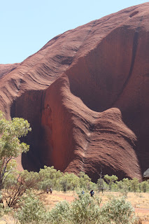
Uluru or Ayer's Rock is a sandstone inselberg (island mountain) nearly at the geographic center of Australia. Called the red center, it rises 1142 ft above the surrounding plain, and is about 5 miles in circumfrence. Together with a nearby feature known locally as the Olgas, it forms the Uluru-Kata Tjula National Park. Uluru is sacred to the Anangu (aboriginal people of the area). It is a UNESCO World Heritage Site and is one of the most recognizable natural landmarks of the continent.
In 1873 it was sighted by a surveyor and named after the Secretary General of South Australia. In 1993. a dual naming policy was instituted, and it became Ayer's Rock/Uluru. (The order of the dual names was officially reversed in 2002 at the request of the local tourism council.) In 1985, the government of Australia returned ownership of the land to the local aboriginal people, with an agreement for a 99 year lease for a national park. Today the national park is managed by a council of 4 aboriginal males, 4 aboriginal females, and 4 representatives of the government.
Tourist features that had sprung up in the 1950s were deemed to be having a negative impact on the sacred land, so a plan was developed to move all the activity to a spot 10 miles north of the national park. The area was developed by a couple of hotels (4 Seasons and Sheraton), but now is totally under one owner -- The Ayers Rock Resort.
To get to the national park, you either have to have a car, or take one of the tours or shuttle buses provided by the resort. I apologize for some of the photos, but shooting out of the window of a moving bus has its problems. We did one loop of the rock, then went to the cultural center.
They do not allow photograpy on some areas of the rock itself due to the religious beliefs of the aboriginal people, as well as in the center itself. Enough words, here are some of the pictures.
 |
| some of the erosion is from water, some is described as chemical |
 |
| Mutitjulu Waterhole |
 |
| just east of Mutitjulu |
 |
| on the south side of Uluru |
 |
| view from parking area trees are desert oaks |
 |
| close up of erosion |


Bucket list item - Check
ReplyDelete